Chart of the Week | Lyon Cornaro atlas, anonymous, 15th century
- Sima Krtalic
- 18 de fev. de 2021
- 4 min de leitura
Date: 15th century
Country: Italy
Archive: Bibliothèque Municipale de Lyon
Call number: ms. 179
Dimensions: 310 x 230
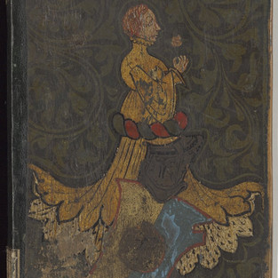
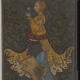
This anonymous 15th century atlas is a luxury collection of four sea charts on parchment pasted onto wooden boards. The atlas takes its name from the escutcheon (coat of arms) of the powerful Venetian Cornaro clan emblazoned on its cover boards, indicating its earliest owners. Attempts at dating the atlas have also sometimes relied on the imagery on the coverboards. By looking at the style of clothing worn by the women painted onto the front and back covers of the atlas, some scholars have argued for a production date in the later decades of the 1400s. This matter remains, however, open to debate.
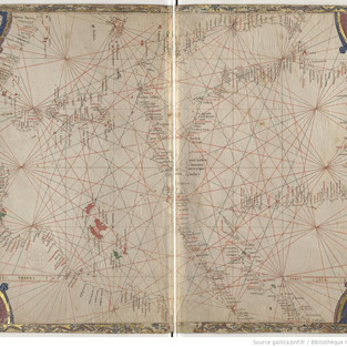
The decoration on the pages of the atlas is unusual. Typically, the illustrations on nautical charts relate to saints, rulers, cityscapes, and mythological creatures. Here, however, we have exquisitely-executed drolleries or grotesques, a staple of medieval illuminated book margins and perennial object of scholarly delight and puzzlement. Implausible bipeds with heads dragging and hind-quarters aloft, with goats’ faces and bats’ wings, now stand vigil on a nautical chart. More surprisingly still, they are not relegated to the pages’ periphery or the hinterlands of regions unknown, but installed in diapered corner pieces.
On the chart of the eastern Mediterranean and Black Sea, we can find clues to the sequence in which the charts in the atlas were completed. Along the North African coast, the straight line of the gilded border is interrupted by several indentations just large enough to fit in some of the placenames. This suggests that the chart’s coastlines and placenames were finished first, and only afterward were the borders added, and adapted to accommodate the existing text and geographical drawings. These two steps may have involved two artisans, each with their own specialty. While the artistic vision of the calligrapher/cartographer/copyist won out in the case of these placenames, on the southeast edge of the chart, the miniaturist evidently decided that their contribution was more important, and did not hesitate to partly obscure a toponym in order to squeeze in another illustration.
The placement of distance scale bars is also curious in this atlas, given its complex interplay between decoration and geographical representation. Scale bars are fitted into seemingly random spaces, and a given chart may have anywhere between three finished scale bars and zero! The chart of the North Atlantic coasts of Europe, for example, includes two gaps to receive scale increments, but the draftsman seems to have forgotten to finish them.
Versão Portuguesa
Este atlas, de autor anónimo, do século XV, é uma coleção luxuosa de quatro cartas marítimas em pergaminho assente em placas de madeira. O nome deste atlas deve-se ao escudo existente no brasão do poderoso clã veneziano Cornaro, que terá sido estampado indicando os primeiros proprietários. Também a datação é muitas vezes baseada nas imagens existentes nas capas do atlas. Assim, observando o estilo de roupa usado pelas mulheres pintadas nas capas frontal e na contracapa, alguns investigadores foram enquadrando o seu período de produção para décadas dos finais de 1400. No entanto, este é um tema que permanece ainda por esclarecer.
A decoração nas páginas do atlas é incomum. Normalmente, as ilustrações nas cartas náuticas referem-se a santos, governantes, paisagens urbanas e criaturas mitológicas. Aqui, no entanto, vemos figuras cómicas, ou grotescas, primorosamente executadas, bastante mais comuns nas margens de livros medievais, e que são objeto de permanente deleite e perplexidade dos estudiosos. Bípedes implausíveis arrastando as cabeças com os quadris no ar, com rostos de cabra e asas de morcego, apresentam-se agora vigilantes numa carta náutica. Surpreendentemente, estes desenhos não foram relegados para a periferia das páginas ou para regiões desconhecidas do interior, mas posicionados nos cantos ornamentados.
No mapa do Mediterrâneo oriental e do Mar Negro, podemos encontrar pistas para a sequência em que os mapas do atlas foram concluídos. Ao longo da costa norte-africana, a linha reta da borda dourada é interrompida por vários recortes suficientemente grandes para caber em alguns nomes de lugares. Isso sugere que as linhas de costa e os nomes dos locais foram concluídos primeiro, e só depois as fronteiras foram adicionadas e adaptadas para acomodar tanto o texto existente como os desenhos geográficos. Essas duas etapas podem ter envolvido dois artesãos, cada um com sua especialidade. Enquanto a visão artística do calígrafo, cartógrafo ou copista venceu nesses nomes de lugares, na fronteira sudeste do mapa, o miniaturista evidentemente achou que a sua contribuição era mais importante e não hesitou em obscurecer parcialmente um topónimo para inserir outra ilustração.
A colocação de escalas de distância também é curiosa neste atlas, dada a sua complexa interação entre decoração e representação geográfica. As barras de escala são encaixadas em espaços aparentemente aleatórios. Um determinado mapa pode ter desde três barras de escala acabadas ou até nenhuma! A carta dos litorais do Atlântico Norte da Europa, por exemplo, inclui duas lacunas para receber incrementos de escala, mas o desenhista parece ter-se esquecido de concluí-las.
Further Reading | Leitura complementar
Ferrand, G. (1931). Les portulans de la Bibliothèque de Lyon. Journal des Savants, 9/1, 394-400.
Pujades, R. J. (2007). Les cartes portolanes: La representació medieval d’una mar solcada. Barcelona, Lunwerg Editores, 136-137.


