Chart of the Week | Vienna atlas of Pietro Vesconte, 1318, Italy
- Sima Krtalic
- 29 de abr. de 2021
- 5 min de leitura
Author: Pietro Vesconte
Date: 1318
Country: Italy (Venice)
Archive: Austrian National Library (Österreichische Nationalbibliothek)
Call number: Cod. 594 (Cimel. 20)
Dimensions: 200 x 190 mm
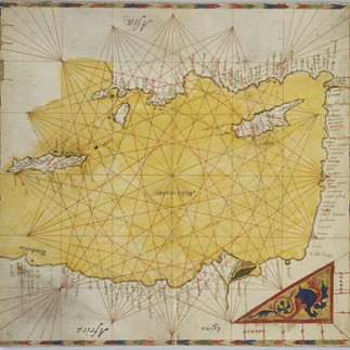
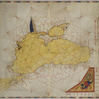
The 1318 Vienna atlas of Pietro Vesconte immediately stands out in the corpus of the great Genoese chartmaker for its atypical stylistic features: its waters are colored in translucent yellowish-green, and its delicate ink coastlines are overpainted in an olive-brown shade. Close comparison reveals striking disparities between the ink coastline and the cruder painted decoration, with the latter obscuring and omitting many of the carefully-placed capes and bays seen in Vesconte’s original drawing. Far from being a Vescontian foray into a new mode of embellishment, this overpainting must be considered a subsequent intervention. It was probably executed by the same (markedly later) hand who inscribed supplemental labels such as “Pontus Exinus” on the Black Sea chart.
The atlas is diminutive, measuring only about 20 cm x 20 cm. Keeping these dimensions in mind, the elegance of Vesconte’s labor is all the more impressive, condensed as his drawings had to be in order to fit on such small parchment sheets. The gilded cornerpieces of these charts are similar to the Vesconte atlases of the Correr Museum atlas of the same year, the ca. 1321 atlas in the Municipal Library of Lyon, and the Perrino Vesconte atlas of around 1320.
The subject matter of the cornerpieces on these four atlases is variable. The iconography of the 1318 Vienna atlas under discussion is of a more restricted character, including only dragons, floral motifs, and a mixture of the two. Nonetheless, juxtaposition of the dragons in the 1318 Vienna atlas with that of the ca. 1321 Lyon atlas underscores the consistency of painting technique in the miniatures across all four luxe atlases. If we accept recent arguments that Vesconte outsourced the illumination of his charts to an established workshop of Venetian miniaturists, as Laura de Marchi has convincingly contended, we can observe in this group of atlases a successful collaboration spanning several years of Vesconte’s output. The 1318 Vienna atlas may represent the earliest result of this highly-effective division of labor.
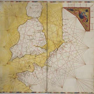
In terms of its geographical coverage, the atlas’s nine charts depict the Mediterranean and Black Seas, and some of the Atlantic Ocean. Some regions (such as the Italian peninsula) are included on more than one chart. Based on the measured lengths of the increments on the miles bars, the charts can be divided into at least three: (1) charts of Spain, the Black Sea, and central Mediterranean from Sicily to Crete; (2) the chart including Sardinia, and the eastern Mediterranean; and (3) the remaining charts of the atlas. Assuming these charts, which include overlapping coastlines, represent faithfully-copied “pieces” of a map with greater geographical coverage, it should be feasible to digitally “reassemble” them into just such a chart. This, however, is not possible for the 1318 Vienna atlas. Although the three charts presenting the western Mediterranean Sea and north Atlantic can be readily linked up (suggesting their derivation from a regional chart of the same area), the situation is more complicated for the rest of the atlas. There are, for instance, massive and irresolvable differences between the configuration of the shared coasts on the map including Sardinia, and that of Spain and the Balearics. How can this be explained? There are two main options. First, Vesconte made gross (and rather uncharacteristic) errors while copying out segments of a larger chart to produce the atlas. And second, the charts were in fact modeled on several unrelated regional depictions, sometimes manifesting mutually-incompatible versions of the Mediterranean coastlines.
Finally, of particular note is the rendering of the British Isles in this atlas and the Correr 1318 atlas, both of which show Scotland for the first time on a nautical chart, joined to England by a slender land bridge. Another first for Vesconte, and nautical cartography in general, is the scale bar, now rendered as a simple rectangle.
Versão Portuguesa
O atlas de Pietro Vesconte de 1318, guardado em Viena, destaca-se claramente do corpus do grande cartógrafo genovês pelas suas características estilísticas atípicas: as águas são coloridas a amarelo-esverdeado translúcido, e às delicadas linhas de costa sobrepõe-se uma sombra castanho-azeitona. Uma atenta observação releva disparidades gritantes entre as linhas de costa originais e a grosseira decoração que lhe foi sobreposta, obscurecendo ou escondendo os cabos e baías cuidadosamente desenhadas no desenho original. Longe de constituir uma incursão vescontiana numa nova forma de embelezamento, esta pintura sobreposta deve ser considerada como uma intervenção posterior, provavelmente executada pela mesma mão que inscreveu legendas suplementares como “Pontus Exinus” na carta do Mar Negro.
O atlas é minúsculo, medindo apenas 20 cm x 20 cm. Tendo em conta estas reduzidas dimensões, a elegância do trabalho de Vesconte é ainda mais impressionante pela miniaturização que o desenho sofreu de modo a caber em tão pequenas folhas de pergaminho. Os cantos dourados destas cartas são semelhantes aos do atlas de Vesconte do Museu Correr, do mesmo ano, do atlas de ca, 1321 da Biblioteca Municipal de Lyon e do atlas de Perrino Vesconte de ca. 1320.
Os temas abordados nos cantos destes quatro atlas são diversos. A iconografia deste atlas de Viena tem um carácter mais restrito, incluindo apenas dragões, motivos florais e uma mistura dos dois. No entanto, a comparação destes dragões com os do atlas de ca. 1321 de Lyon evidencia a consistência da técnica pictórica utilizada nas miniaturas destes quatro luxuosos atlas. A aceitar o recente argumento de que Vesconte encomendou a iluminação das suas cartas a uma oficina conceituada de miniaturistas venezianos, tal como Laura de Marchi defendeu de forma convincente, poderemos observar neste grupo de atlas uma colaboração bem sucedida que se manteve muitos anos. Assim, este atlas de 1318 de Viena pode constituir o primeiro resultado da tão eficaz divisão de trabalho.
Quanto à cobertura geográfica, as nove cartas do atlas representam o Mediterrâneo, Mar Negro e parte do Oceano Atlântico. Algumas regiões (tal como a península Itálica) constam em mais de uma carta. Com base nos comprimentos medidos nas escalas de distância, graduadas em milhas, as cartas podem ser organizadas em, pelo menos, três grupos, de acordo com as respectivas escalas: (1) cartas de Espanha, Mar Negro e Mediterrâneo central, da Sicília a Creta, (2) cartas que incluem a Sardenha e o Mediterrâneo oriental; e (3) as restantes cartas do atlas. Assumindo que estas cartas, que partilham algumas linhas de costa, são cópias fiéis de partes de um modelo com maior cobertura geográfica, deveria ser possível reconstituir digitalmente tal modelo na forma de uma carta única. Contudo, tal não é possível para o atlas de Viena de 1318. Embora as três cartas que representam o Mediterrâneo e o Atlântico Norte sejam facilmente relacionadas entre si (sugerindo serem derivações de uma carta regional dessa área), a situação é mais complicada para o resto do atlas. Existem, por exemplo, diferenças consideráveis e irreconciliáveis entre as configurações das linhas de costa partilhadas pela carta da Sardenha e pela que inclui Espanha e as Ilhas Baleares. Como pode isto ser explicado? Há duas razões possíveis. A primeira, que Vesconte cometeu erros grosseiros (e incaracterísticos) na cópia dessas parcelas a partir de uma carta mais geral, para a produção do atlas; e a segunda, que essas cartas foram copiadas de representações regionais não relacionadas entre si, relevando por isso incompatibilidades entre as respectivas versões.
Finalmente, é de evidenciar, neste atlas e no que está conservado no Museu Correr, a representação das Ilhas Britânicas. Em ambos, e pela primeira vez em cartografia náutica, a Escócia é representada com uma estreita ligação a Inglaterra. Outra novidade, para Vesconte e para a cartografia náutica em geral, é a escala de distâncias, agora representada como um simples rectângulo.
Further Reading | Leitura complementar
Campbell, Tony. “Cartographic Innovations by the Early Portolan Chartmakers.” Accessed 1 April 2021 (link)
De Marchi, Laura. "Come antiche preghiere. Gli atlanti veneziani del Vesconte." Rivista di storia della miniatura 19 (2015): 46-57.
Brentjes, Sonja. "Medieval portolan charts as documents of shared cultural spaces." Acteurs des transferts culturels en Méditerranée médiévale. Oldenbourg Wissenschaftsverlag, 2013. 135-146.
Sheehan, Kevin. The Functions of Portolan Maps: An evaluation of the utility of manuscript nautical cartography from the thirteenth through sixteenth centuries. Diss. Durham University, 2014.


Comments